
Biodiversity Conservation
Specialised training to equip local communities in the Cook Islands to undergo participatory three-dimensional modelling (P3DM) started this week for the district of Vaka Puaikura on Rarotonga.
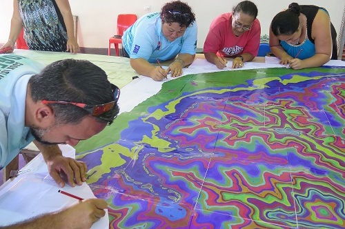
The purpose of a P3DM is to provide the community with a birds-eye view of important areas within the village, which includes dwellings, ra'ui sites (coastal protected areas), native and endemic trees, marae, churches and other features that the community sees as a valuable resource to be highlighted onto a 3D model.
"We look forward to developing this tool for the benefit of the people of Vaka Puaikura. We gather here to work together as a community on something that I believe will benefit all of us and generations to come," said Mr Joseph Brider the Director of the Cook Islands National Environment Service.
 Members of the Cook Islands National Environment Service and the community
'tracing', one of the first steps of the P3DM process
The 5-day training is a key activity of the Cook Islands Global Environment Facility Pacific Alliance of Sustainability - Integrated Island Biodiversity (GEFPAS IIB) Project executed by the National Environment Service in collaboration with the Secretariat of the Pacific Regional Environment Programme (SPREP), the Government of Samoa - Ministry of Natural Resource and Environment, the Government of Tonga GEFPAS IIB Project, the Technical Centre for Agricultural and Rural Cooperation (CTA), the UNDP-Adaptation Fund Cook Islands Strengthening Resilience in Communities to Climate Change Project, and all the key agencies, organisations and communities of Vaka Puaikura of the Cook Islands.
The training brings together community members and government officers from relevant ministries to familiarise them with the P3DM approach, process and practical application which will have them contributing hands on to the construction of a Three-Dimensional model of their district.
The Vaka Puaikura is the first district on the island of Rarotonga to receive this training and construct a P3D model. The expansion of this initiative to other districts and islands in the Cook islands is planned for the near future.
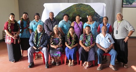 The Cook Islands P3DM Team
"We have started the Cook Islands P3DM and start building the three-dimensional map for the community of Vaka Puaikura. Everyone is invited to come and have your say and share what information you hold," said Ms Mii Matamaki, National Coordinator for the Cook Islands GEFPAS IIB Project.
The training will wrap up on Friday 17 June with the unveiling of the P3D model for the district of Vaka Puaikura. The P3D model will assist the district with conservation and broader land use planning.
The training is held at the Aroa Nui Hall in Vaka Puaikura from 13 - 17 June 2016.
The GEFPAS Integrated Island Biodiversity Project is funded by the Global Environment Facility, implemented through the United Nations Environment Programme and executed by the Secretariat of the Pacific Regional Environment Programme in the Cook Islands, Nauru, Tonga and Tuvalu.
The purpose of a P3DM is to provide the community with a birds-eye view of important areas within the village, which includes dwellings, ra'ui sites (coastal protected areas), native and endemic trees, marae, churches and other features that the community sees as a valuable resource to be highlighted onto a 3D model.
"We look forward to developing this tool for the benefit of the people of Vaka Puaikura. We gather here to work together as a community on something that I believe will benefit all of us and generations to come," said Mr Joseph Brider the Director of the Cook Islands National Environment Service.
Members of the Cook Islands National Environment Service and the community 'tracing', one of the first steps of the P3DM process
The training brings together community members and government officers from relevant ministries to familiarise them with the P3DM approach, process and practical application which will have them contributing hands on to the construction of a Three-Dimensional model of their district.
The Vaka Puaikura is the first district on the island of Rarotonga to receive this training and construct a P3D model. The expansion of this initiative to other districts and islands in the Cook islands is planned for the near future.
The Cook Islands P3DM Team"We have started the Cook Islands P3DM and start building the three-dimensional map for the community of Vaka Puaikura. Everyone is invited to come and have your say and share what information you hold," said Ms Mii Matamaki, National Coordinator for the Cook Islands GEFPAS IIB Project.
The training will wrap up on Friday 17 June with the unveiling of the P3D model for the district of Vaka Puaikura. The P3D model will assist the district with conservation and broader land use planning.
The training is held at the Aroa Nui Hall in Vaka Puaikura from 13 - 17 June 2016.
The GEFPAS Integrated Island Biodiversity Project is funded by the Global Environment Facility, implemented through the United Nations Environment Programme and executed by the Secretariat of the Pacific Regional Environment Programme in the Cook Islands, Nauru, Tonga and Tuvalu.