La Niña conditions are very likely to establish across the Pacific over the coming three months, according to the official statement released after the recently concluded 17th convening of the Pacific Islands Climate Outlook Forum (PICOF-17) in Port Vila, Vanuatu.
The statement, produced by the World Meteorological Organization Regional Association V (WMO RA V) Pacific Regional Climate Centre Network provides critical guidance for Pacific National Meteorological and Hydrological Services (NMHSs) across 15 countries as they prepare for the November 2025 to April 2026 Tropical Cyclone Season.
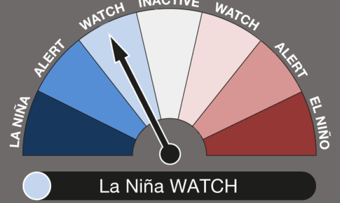
According to the statement, weak La Niña conditions are likely to be established from November 2025 to January 2026. A weak La Niña event means its peak and duration will not reach levels experienced by major La Niña events that have developed in the Pacific, and will be short-lived, and conditions will return to neutral in the first quarter of 2026.
What is La Niña?
La Niña is the name given to the phenomenon where the trade winds across the Pacific become stronger, pushing the warm pool in the Pacific ocean further to the Western Pacific. This causes sea surface temperatures to increase in countries in the Western Pacific such as Palau, Papua New Guinea, Solomon Islands and Vanuatu, while countries in the Central and Eastern Pacific such as Nauru, Kiribati, Tuvalu, Tokelau, Cook Islands, and French Polynesia experience cooler sea surface temperatures.
A La Niña event is declared when both ocean and atmospheric thresholds are observed. During the PICOF-17, Pacific NMHSs and technical partners who are members of the Pacific Regional Climate Centre Network came to a consensus that a weak La Niña is likely to develop in the Pacific.
La Niña is part of the El Niño-Southern Oscillation (ENSO), which is a major climate driver that influences rainfall, temperature, and sea level patterns across the Pacific.
What happens during a La Niña Event?
When La Niña conditions develop in the Pacific, the impacts are different for countries in the Western Pacific and in the Central and Eastern Pacific.
For countries in the Western Pacific, a La Niña event will result in higher than normal rainfall. This means that countries will be more prone to flooding and landslides, especially as they head into the tropical cyclone season from November to April. Countries will also experience warmer oceans, and coastal inundation as sea surface temperatures increase, as well as higher sea levels. The chances of tropical cyclones forming during this period will be higher for countries in the Western Pacific.
For the Central and Eastern Pacific, a La Niña will result in less rainfall, meaning that countries like Nauru, Kiribati, Tuvalu, Tokelau, parts of Cook Islands, Papua New Guinea, Federated States of Micronesia, Republic of the Marshall Islands, and French Polynesia will be more prone to droughts during this period. A La Niña will also result in cooler ocean temperatures, as the trade winds blow the warm pool farther to the West, lowering the sea surface temperatures around these countries. Tropical cyclones are less likely to form during a La Niña event, which will be welcomed news by countries in the Central and Eastern Pacific heading into this tropical cyclone season.
Communities are encouraged to contact their National Meteorological Services for more information on the La Niña event and its impacts in their respective countries, and how best to prepare for this event. They can also reach out to regional organisations such as the Pacific Community (SPC) and the Secretariat of the Pacific Regional Environment Programme (SPREP) for more information.
To access the full PICOF-17 Regional Statement, please visit this link.