
Climate Change Resilience
El Niño conditions can be expected across the Pacific region by the end of this year, according to the latest Island Climate Update issued today by the Pacific Island Meteorological Services, SPREP and NIWA.
Recent weather observations confirm that the ocean and the atmosphere across the Pacific are responding to 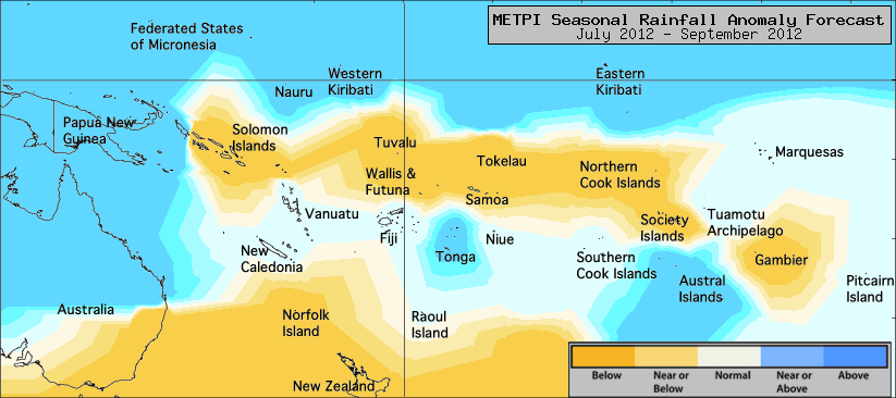 changing climatic forces, and climate models indicate this trend will continue through the southern hemisphere winter.
changing climatic forces, and climate models indicate this trend will continue through the southern hemisphere winter.Historically, El Niño conditions have caused decreased rainfall in the western Pacific and increased rainfall in the central and eastern Pacific (e.g. Tuvalu, Nauru and Kiribati). During the most recent El Niño period (2009-2010), low rainfall was experienced in the western Pacific, which caused water rationing in Fiji and the northern islands of Vanuatu.
The predicted El Niño will contrast with the recent La Niña conditions over the past 2 years which have caused drought in the central eastern Pacific and heavier than normal rainfall in the western Pacific.
One of the most significant impacts on El Nino in the Pacific islands region is a shift in the South Pacific Convergence Zone northwards and westwards. In addition to moving the zone of heavy rain toward the 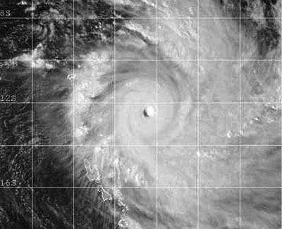 equatorial Pacific, it means tropical cyclones form further northward than normal.
equatorial Pacific, it means tropical cyclones form further northward than normal.This means an increased risk of stronger tropical cyclones affecting island countries to the south such as Samoa, Fiji, Vanuatu, the Cook islands, Niue and Tonga. During past El Niño cyclone seasons (from November to April), more cyclones also occurred to the east of the dateline.
"After several relatively quiet seasons, signs are ominous for the coming tropical cyclone seasons with more cyclones likely in the region, and those that form are more likely to reach destructive hurricane force," said Neville Koop, the Meteorology and Climatology Advisor at SPREP.
Read the full Island Climate Update.
You can also contact: your local Meteorological Service, The Secretariat of the Pacific Regional Environment Programme (SPREP) - nevillek@sprep.org, or the National Institute of Water and Atmospheric Research (NIWA) - nicolas.fauchereau@niwa.co.nz
Cyclone image: Severe Tropical Cyclone Zoe, one of the strongest cyclones recorded in the south west Pacific region, is seen here on December 28 2002 passing between Fiji and Vanuatu. Earlier this cyclone passed over the eastern islands of the Solomon Island archipelago devastating the islands of Anuta and Tikopia. At the time of this image TC Zoe had winds gusting to 350kmph near the centre. TC Zoe formed during the 2002/2003 El Nino event. Its formation well north of 10 degrees south latitude and its stronger than average intensity are consistent with the influence exerted by the evolving El Nino at this time.