
The Pacific is about to enter an episode of El Niño, however the signal is mainly being seen in the ocean temperature, and not yet in the atmospheric circulation, according to the latest Island Climate Update.
El Niños are usually characterised by reduced easterly trade winds and warmer sea surface temperatures around the dateline in the equatorial Pacific. Monitoring buoy and satellite measurements have shown that the ocean is warmer than usual in the central Pacific (by 0.7°C), but that the easterly trade winds in the central Pacific are still blowing at their usual strength for this time of year.
This could indicate that the predicted El Niño will not be as strong as other recent events, so reduces the expected extreme droughts and rainfall.
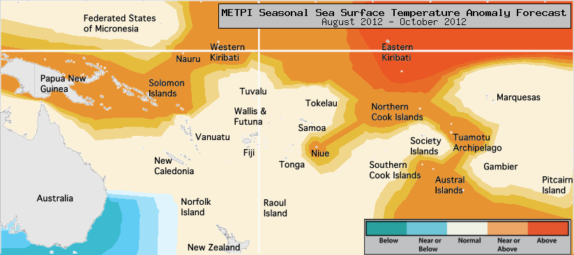 Predicted sea surface temperatures around the Pacific for the coming months of August to October. Warmer than usual waters in the equatorial Pacific (orange to red) indicate El Niño conditions, which brings more rainfall to islands in the central equatorial Pacific, and less rainfall to other regions
Over the coming three months, normal or below normal rainfall is forecast for Fiji, Samoa, the Society Islands, the Tuamotu Archipelago and Wallis & Futuna. Normal to above normal rainfall is expected for Western and Eastern Kiribati, Tonga and Pitcairn Island.
The Island Climate Update is a monthly publication prepared by the Pacific National Meteorological Services, NIWA and SPREP. It provides a review of current and forecast weather in the Pacific region.
For more information please contact your local National Meteorological Service, the National Institute of Water and Atmospheric Research (NIWA), nicolas.fauchereau@niwa.co.nz, or the Secretariat of the Pacific Regional Environment Programme (SPREP), nevillek@sprep.org.
For the full island climate update, see http://www.niwa.co.nz/climate/icu.