
21 April 2023, Apia – The Pacific has just come out of a triple-dip La Niña event, to an El Niño Watch being declared by four organisations under the Pacific Regional Climate Centre node for long-range forecasting.
The recent Pacific Islands Climate Outlook Forum (PICOF-12) was highlighted as an important forum for Pacific National Meteorological and Hydrological Services (NMHSs), as the possibilities over the next six months, especially in relation to rainfall and temperature and their impacts, needs to be communicated clearly to in-country stakeholders.
This was the message from the Secretariat of the Pacific Regional Environment Programme’s (SPREP) Director of Climate Change Resilience, Ms Tagaloa Cooper, at the 12th gathering of Pacific NMHSs and technical experts and partners held yesterday.
“It is our duty to ensure that information on climate science shared in this forum reaches the last mile in our countries, so that stakeholders and people can prepare,” Ms Cooper said.
“What we do now will determine how people can prepare for and attempt to minimise the adverse impacts of the potential upcoming El Niño event,” she added.
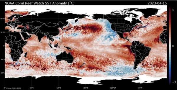
El Niño is part of a major climate driver in the Pacific – the El Niño-Southern Oscillation (ENSO). ENSO is a slow onset event, and El Niño is the name given to the phenomenon characterised by reduced easterly trade winds and warmer sea surface temperatures for countries along the dateline and close to the Equator.
The phenomenon will result in a number of impacts on Pacific Island countries, such as increased rainfall for countries in the central and eastern Pacific such as Nauru, western and eastern Kiribati, Tuvalu, Tokelau, northern Cook Islands and northern French Polynesia making them prone to flooding, landslides and damage to infrastructure.
Countries in the Western Pacific, such as Fiji, Palau, Papua New Guinea, Samoa, Tonga, Vanuatu and Wallis and Futuna, will see normal to below normal rainfall, and will likely experience droughts during the El Niño period.
The last El Niño event in the Pacific occurred in 2015-2016, and Ms Cooper stressed the importance of effective early warning systems within Pacific Island countries, through their NMHs, in ensuring that communities are prepared and can mitigate the impacts of El Niño on their livelihoods.
“It is our duty to ensure that information on climate science shared in this forum reaches the last mile in our countries, so that stakeholders and people can prepare,” Ms Cooper said.
So far, the Australian Bureau of Meteorology, APEC Climate Centre, the National Institute of Water and Atmospheric Research, and the National Oceanic and Atmospheric Administration have all declared an El Niño watch.
Current ENSO outlooks show that ocean temperatures have warmed by 3-5 degrees Celsius off the coast of south America, and the warm water from the West Pacific Warm Pool is discharging eastward by way of changes in the trade winds. These signs and model forecast are all favouring an El Niño event developing as the year progresses.
The national Hydrological and Meteorological Services (NMHS) will continue to monitor the current development of potential El Niño through the monthly Ocean and Climate Outlook Forum (OCOF) and the National Climate Outlook Forums (NCOFs). People are encouraged to use the NMHS to get official information on the current climate situation and predictions for the next six months.
For more information, please contact the Pacific Meteorological Desk Partnership at pacmetdesk@sprep.org or your local National Meteorological and Hydrological Service.