
10 June 2022, Apia - Government stakeholders of the Republic of Nauru are now equipped with hands-on, practical knowledge of finding relevant up-to-date data, information resources and technical guidance to assist planning for protected and conserved area establishment and management.
They are also able to use spatial data and Geographic Information System (GIS) software to produce and export basic protected area maps with standard features.
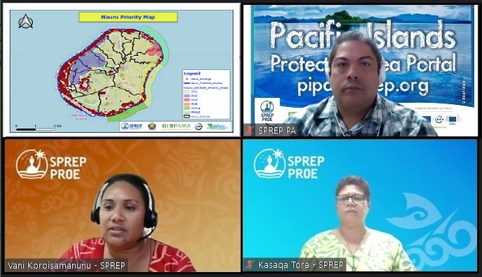
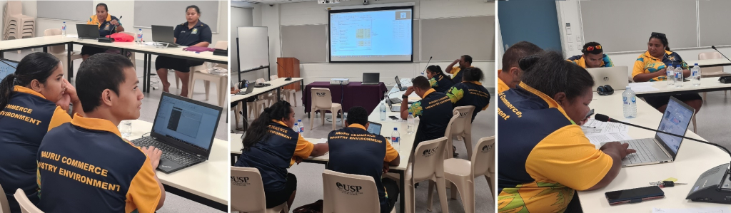
It follows a virtual training on the tools and features of the Pacific Islands Protected Area Portal (PIPAP) and GIS co-organised by the Secretariat of the Pacific Regional Environment Programme (SPREP) and the Nauru Department of Commerce, Industry and Environment (DCIE).
The staff of the Nauru Department of Climate Change and National Resilience also participated.
The Director for Environment DCIE, Mr Bryan Star, said the skills and knowledge gained through the training would greatly assist Nauru with planning and decision-making processes, especially regarding proposed conservation areas that have been identified on Nauru through past studies.
“Through hands-on exercises we learnt that the Pacific Islands Protected Area Portal is a reliable source of consolidated information and decision support tools and we acquired valuable technical skills to produce site maps with ease,” said Mr Star.
“The training has been a valuable experience especially for those who were able to participate over the two days. I convey my sincere appreciation to them accordingly. This training addresses a key priority for Nauru, and we are very grateful to SPREP and the BIOPAMA Programme for this support and assistance.”
On the first day of the training, an overview of importance of protected and conserved areas was given to provide context, followed by a brief introduction and online demonstration of the tools and features of the PIPAP. These were complemented by practical exercises where participants learnt how to access and conduct simple interpretation of their national protected area data, carry out basic and advanced searches for information resources using the portal’s search function, create descriptive site-based profiles and drawing basic site boundaries, and accessing decision support tools and technical guidance on different aspects of protected and conserved area planning and management available through the portal.
Day two covered the basic concepts of GIS and provided participants with practical skills in the use of free open-source software (QGIS) to view existing Nauru spatial datasets, add and manipulate spatial data layers and produce basic site maps with a standard layout - title, scale, descriptive labels, legend and clear boundaries. Furthermore, participants learnt how to export the maps to different formats.
“A key objective of this training was to demonstrate the relevance of, and value, that the PIPAP portal and GIS skills can add to different aspects of the participants’ daily work, especially as it relates to future planning processes. I am happy that we have been able to deliver on this priority capacity need for Nauru, collaborating closely with our colleagues at DCIE,” said Mr Vainuupo Jungblut, Protected Areas Officer, SPREP.
“Follow-up technical assistance will be provided in the coming months, as required.”
The PIPAP and GIS training to Support Protected and Conserved Area Planning and Establishment, for Nauru, held8-9 June 2022 was funded through the BIOPAMA Programme, an initiative of the Organisation of African, Caribbean and Pacific (OACPS) Group of States financed by the European Union 11th European Development Fund.
In the Pacific, the project is implemented by IUCN Oceania in partnership with SPREP and the European Commission Joint Research Centre. This partnership has assisted the SPREP Regional Programme of Support for Protected Areas (SPREP-PA) to become a decision-making support hub, including delivering capacity building activities and training in the use of BIOPAMA support tools and services.
It has also seen significant enhancements of the Pacific Islands Protected Area Portal, the region’s one-stop resource for protected area information. Additional GIS support for the training was provided by the GEF-funded regional Inform Project implemented through UN Environment and executed by SPREP. For more information on national Nauru datasets please visit the Nauru Environment Data Portal.
To learn more about the BIOPAMA regional decision-making support hub, please contact Mr. Vainuupo Jungblut, Protected Areas Officer on email: vainuupoj@sprep.org
For more information on the Inform Project and national environment data portals, please contact the Inform team via inform@sprep.org